Elevations
Advertisement
Geodaten International Admin
Geo data international world-wide with towns, town quarters and postal codes. Georeferences as UTM- and geographic coordinates (WGS84) and elevations. Suitable for branch searches, periphery searches and distance computations. Australia, Austria,
Scalextric Track Designer v.1. 1. 2002
Scalextric Track Designer is the ultimate track building tool! This excellent 3D software includes the full Scalextric track inventory and comes complete with a built-in room designer.
E QuickSections v.3.0
'E Quick Sections - CAD' is a compact and powerful utility to generate sections directly in CAD from data available in drawing.
NetZoomDC Enterprise Client v.10 1
NetZoomDC Enterprise is a powerful, fully scalable, all-in-one, datacenter worker solution that enables you to achieve operational productivity and capacity efficiencies in datacenters.
Plan-G v.2.0.5.493
Plan-G is a freeware VFR flight planning tool for Microsoft Flight Simulator X and 9.
The Simple Hydraulic Calculator v.1. 4. 2008
Powerful and affordable hydraulic calculation software for automatic fire sprinkler systems. TSHC has all the features you need to enter system data, evaluate and analyze results, and produce professional hydraulic calculation reports.
GeoMapApp v.3.1.6
GeoMapApp is an earth science exploration and visualization software that is continually being expanded as part of the Marine Geoscience Data System (MGDS) at the Lamont-Doherty Earth Observatory of Columbia University.
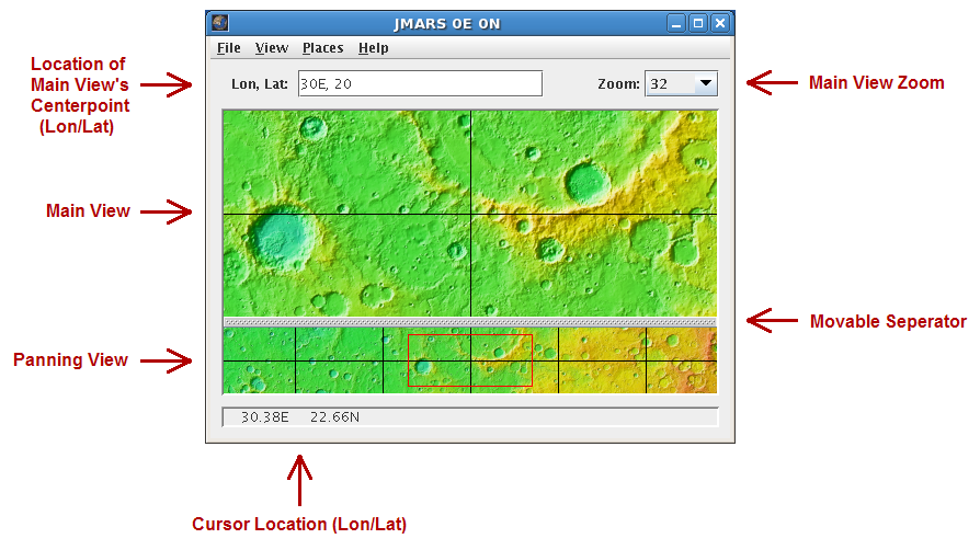
JMARS v.1.25
JMARS is an acronym that stands for Java Mission-planning and Analysis for Remote Sensing.