Elevations
Advertisement

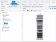
NetZoom v.15
NetZoom is a software application for tracking and managing assets in small to medium size data centers, server rooms and IT rooms. In NetZoom users can model data center floor layouts, manage rack elevations and servers and track assets.
Advertisement
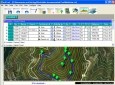
EMapZone v.4.5.0.3
- Prepare a trip on any map from a scanner - Obtain total distances and elevations in a flash (some altitudes have to be set) - Print a personalized map at any scale for terrain use - Print the elevation curve at the required scale
Quickie Architect v.5.0
This CAD drawing software offers 150 pre-drawn floor plans and a 1,000-piece symbol library. You can create floor plans, elevations, landscape plans and more with ease using the intuitive and extensive array of drafting tools.
Geodata International v.10.05
Geodata International - World-wide database of countries with georeferenced towns, municipalities, postal codes and administrative units with WGS84 and UTM coordinates and elevations for geocoding, proximity search, navigation, distance calculation.
Geodaten International v.6.01
Geodata International - World-wide database of countries with georeferenced towns, municipalities, postal codes and administrative units with WGS84 and UTM coordinates and elevations for geocoding, proximity search, navigation, distance calculation.
ORTWIN v.13.02
ORTWIN is a program for the inquiry of localities in Germany. It finds postal zip codes, telephone pre selections, coordinates. It performs perimeter searches and distance calculations. It finds landscapes, natural units, snow- and wind load zones.
EdiTrail v.1.0
Create/Edit/Display/Management/Import/Export Trails/Routes in a simple and flexible environment divided in a data table for the management of trails and a map resulting from numerous providers, (Bing, Arcgis, Ovi, Yahoo, etc).
Fallen Evolution v.16 9
Fallen Evolution is a MMORPG with tons of features.
Scalextric Track Designer v.1. 1. 2002
Scalextric Track Designer is the ultimate track building tool! This excellent 3D software includes the full Scalextric track inventory and comes complete with a built-in room designer.
ArchiTECH.PC v.6.0.82
ArchiTECH.PC is one of the rare, independent design applications that includes all aspects of architectural design and display, concentrated into a single program.
TopoLT v.10.4
Currently, the license distribution is and provided by CADWARE Engineering, while the producer 3D Space which has a rich experience in office buildings and residential design is continuing to research and develop the applications.